 |
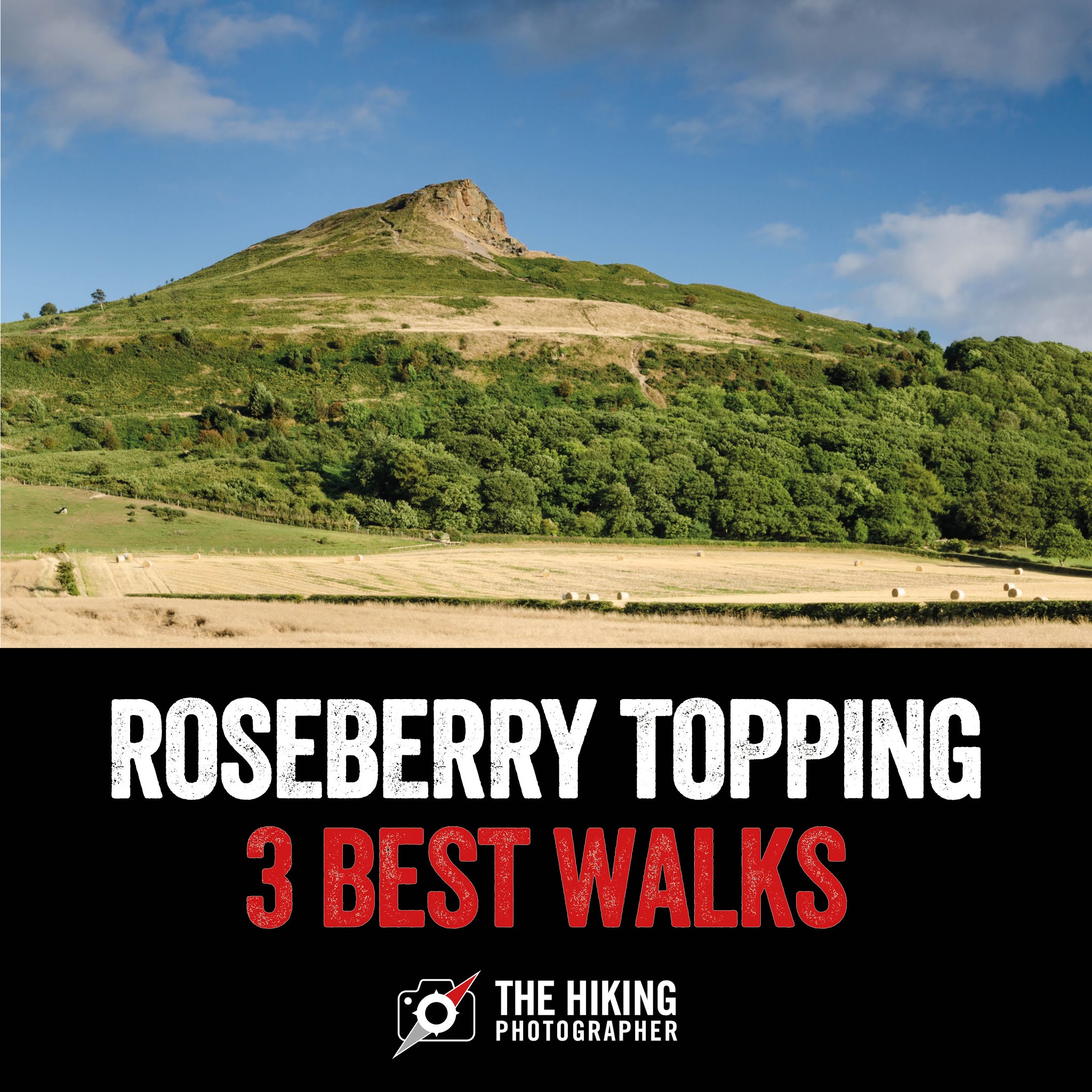
| Roseberry Topping is a distinctive and iconic landmark with a 'fin' like shape and is a very noticeable peak on the Cleveland Hills. It's a brilliant destination for a walk for all ages. |
The 3 best Roseberry Topping walking routes that you need to know about
Roseberry Topping is a well-known and much-loved popular walking destination for many people in the Teesside and North-Yorkshire area. You can see it from miles around which makes you just want to walk to the top of it. However there are multiple walking routes around Roseberry Topping, with some fantastic hidden views that many people do not know about when planning their Roseberry Topping walk. I live in the Teesside area and I've lost count of the number of times I've walked to the top of Roseberry Topping - read on to discover my 3 favourite Roseberry Topping walking routes which are of varying distances and difficulty, but first here's an FAQ on Rosebrry Topping:
Life Insurance
How high is Roseberry topping?
Roseberry Topping is 320m high (1,049ft) and whilst not the biggest hill you'll ever see it's a very distinctive local landmark that just needs to be tackled on a walk as it gives some of the best views in the area.
How long is the walk up to Roseberry Topping?
It depends on the walking route you take, with the shortest walk being 1.3 miles there and back and can be done in an hour. There are longer Roseberry Topping walking routes and multiple paths to the summit, and the 3 best routes in my humble opinion are featured on this blog post.
Is Roseberry Topping a difficult walk?
It's quick to walk up to the summit of Roseberry Topping, but it does get steep in parts (whilst being perfectly safe). It is a great walk for all ages, from kids as young as 3 and for those with a reasonable level of fitness and mobility.
Where do you park to walk Roseberry Topping?
Roseberry Topping has its own car park nearby on the A173 maintained by the National Trust (Post code: TS9 6QS). It can get quite busy on weekends and will cost you a few quid to park. If this car park is busy - there's another pay & display car park about 300 yards north up the A173 road past the King's Head Inn (make sure you do purchase a parking ticket as the wardens are quite on the ball around these parts unfortunately).
Life Insurance
 |
| Read on to learn about the 3 best Roseberry Topping Walks! |
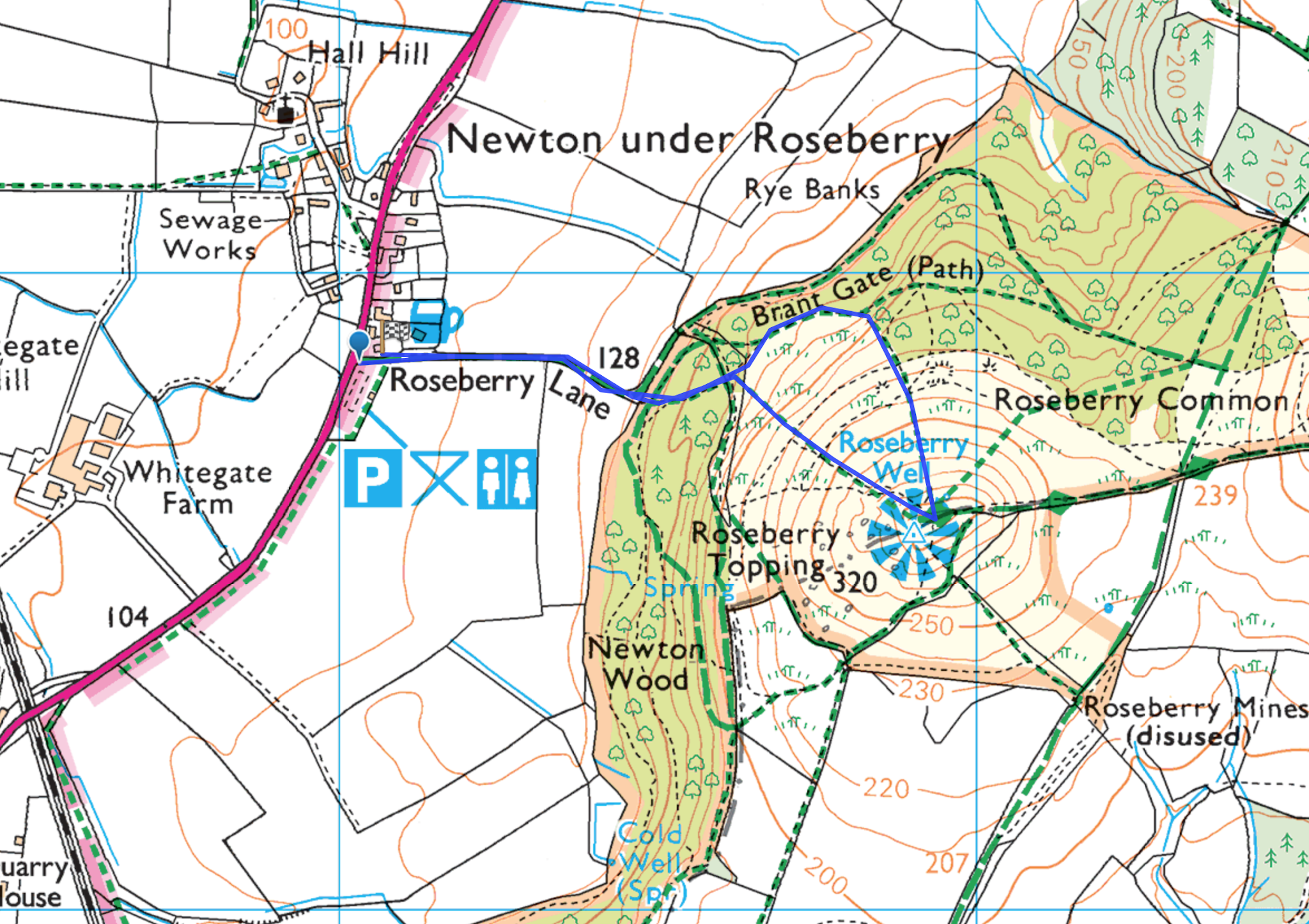
#1. The quickest Roseberry Topping walk (ideal for families)
This is the quickest and most direct way to tackle Roseberry Topping - which starts at the Roseberry Topping Public Car Park (TS9 6QS). It's about 1.3 miles there and back and the total walk can be done in about an hour depending on your fitness and time at the top :-)
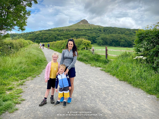 |
| I do this route often with my young family and it only takes us about an hour in total. Ella & Charlie where both 4 when they first got to the top with no carries so I'm sure most will be fine on this route:-) The walk starts off flattish up Roseberry Lane - where Roseberry Topping is in full view. This is the most direct route up to Roseberry Topping and the quickest Roseberry Topping walk. It's pretty much 'as the crow flies' to the summit and the path just heads straight for the summit as depicted in this photo with some steps at various parts where you'll get out of breath a touch but its nothing too strenuous. |
Roseberry Topping quick walk overview details:
Roseberry Topping walk total distance: 1.3 miles (2.2km)
Roseberry Topping walk total time: 1 hour
Walk Difficulty: Moderate - it's short but steep in parts
Life Insurance
 |
From the car park you had up the flat Roseberry Lane and then you'll come to some steps and then it's a bit of a steepish slog to the top. With 2/3 stops and a couple of benches on the way it's fine for kids aged 4+ and will probs take you 30 mins or so to reach the top. There are some great views at the top and take some snacks and a drink for the summit to admire the views. We like to come down a different the path to the north of the summit which is steep also and grassy - but the kids find it funny as you can pick up some speed! You can of course just come back down the way you went up or extend your walk a touch and come down the east side. Whatever route you come back down its much quicker and easier. All in all you should be able to this full circular walk in about an hour. Click the button below to view the interactive map route and download it to keep you on track (OS Maps subscription required to view all features)
|
If you don't have a Phone Map App - I really recommend the one by Ordnance Survey. You can download route maps to your phone such as this one and the app will show you exactly where you are on the route even when you have no signal - so no more taking a wrong turn :-)
Life Insurance
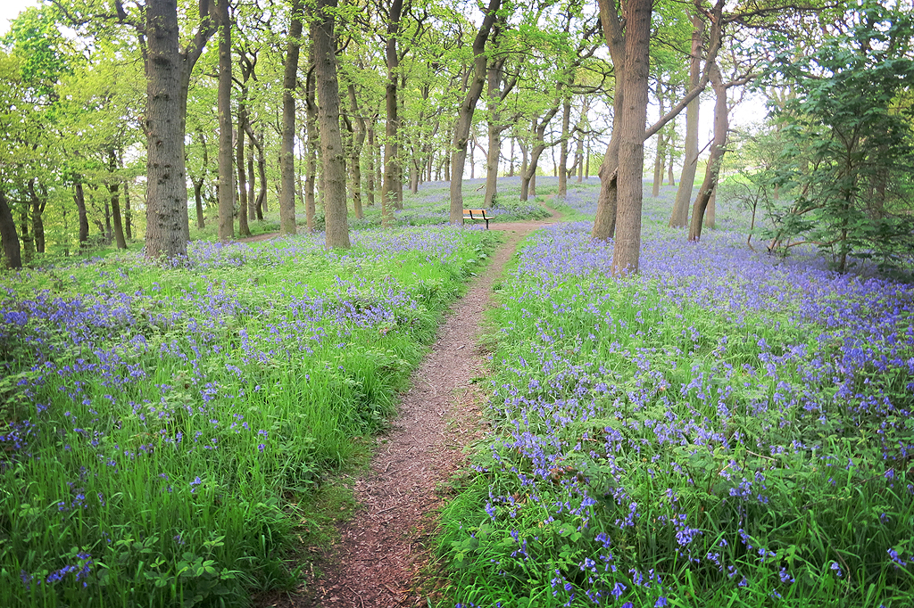
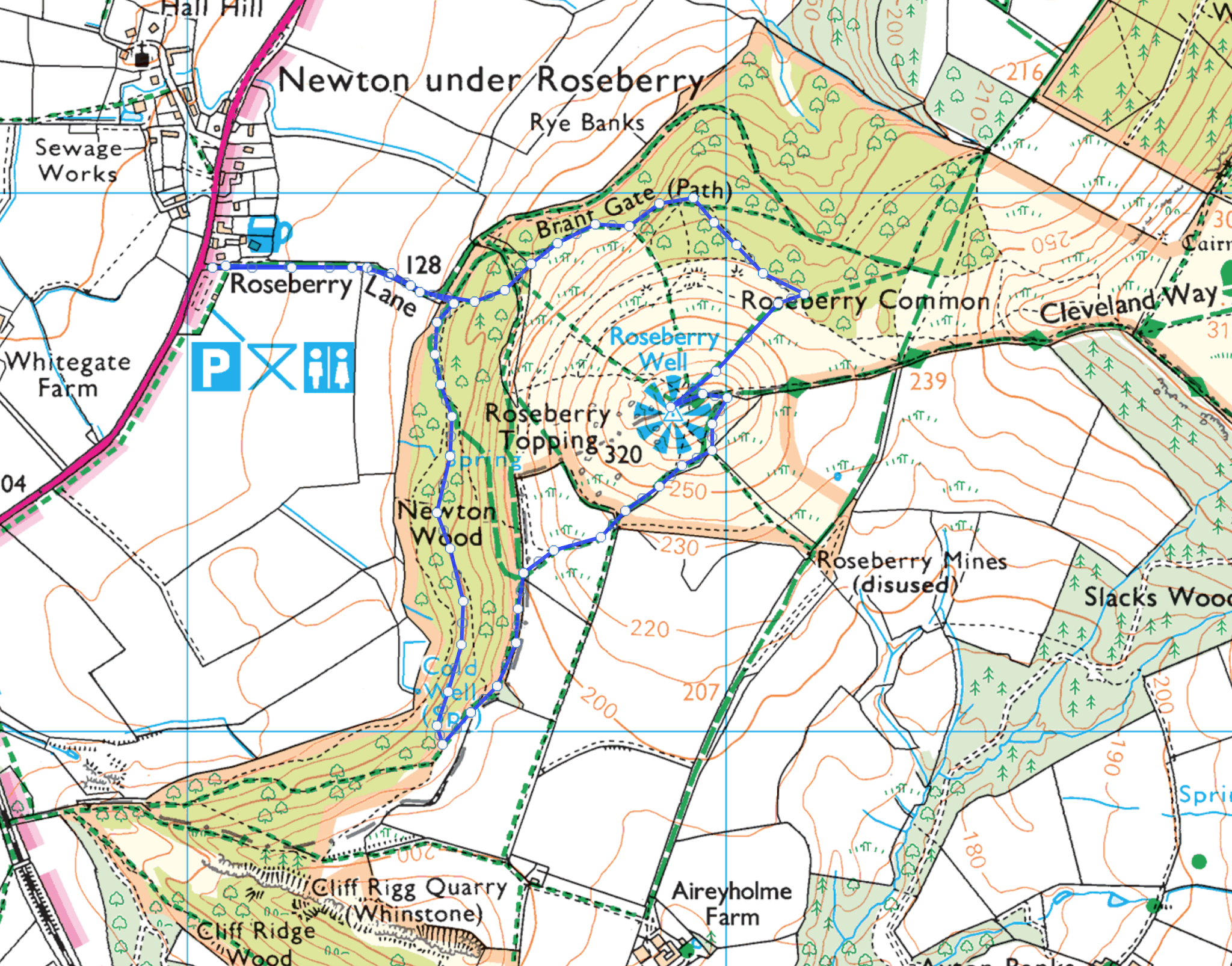
#2. The stunning bluebell walk route through Newton Wood with some of the best views of Roseberry Topping
 |
| Roseberry Topping with the Bluebells in Newton Wood in the foreground. I try and visit this specific location every May or early June time when the Bluebells are in full bloom. It's a stunning sight and not to be missed if you are planning your Roseberry Topping walk in these months. See below for the specific location of the view in this photo and the full walking route is further down the page. |
 |
| This map shows the location (pink circle) within Newton Wood to get the best view of Roseberry Topping and the Bluebells. The map below will take you on a walk through Newton Wood and then to the summit of Roseberry Topping. |
 |
| You'll see plenty of Bluebells on this walk of you do it in May/June when they are in full bloom - it's a special sight to see. |
Life Insurance
Roseberry Topping 'Bluebell' wood overview details:
Roseberry Topping Walk Total Distance: 2.4 miles (3.9km)
Roseberry Topping Walk Total Time: 1.5 hours
Roseberry Topping Walk Difficulty: Easy
 |
This Roseberry Topping walk starts again from the public Car Park (TS9 6QS) and again heads up Roseberry Lane, you then take a right into Newton Wood instead of heading straight to the summit and the walk goes in an anti-clockwise direction. Newton Wood is a nice little woodland walk at any time, which is made all the more special by the flowering Bluebells in May/early June. This is a gentler way to walk up to the Roseberry Topping summit that isn't as steep as the quick route above. This route is a much more varied walk and if you have the time - this is the best Roseberry Topping walking route that I would recommend. Click the button below to view the full interactive map (OS Maps subscription required to access all features - the phone app is well worth downloading )
|
#3. The best long Roseberry Topping circular walk from Great Ayton, via Captain Cooks Monument on the Cleveland Way
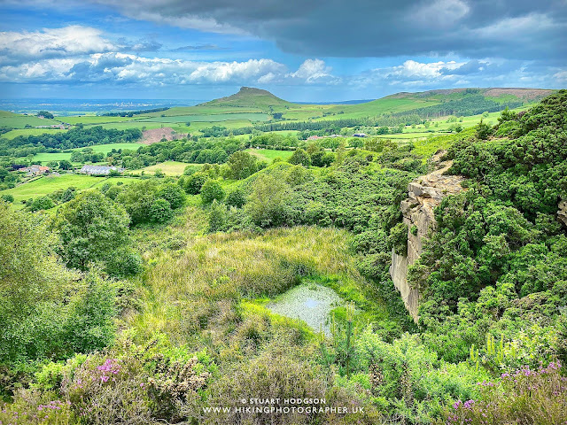 |
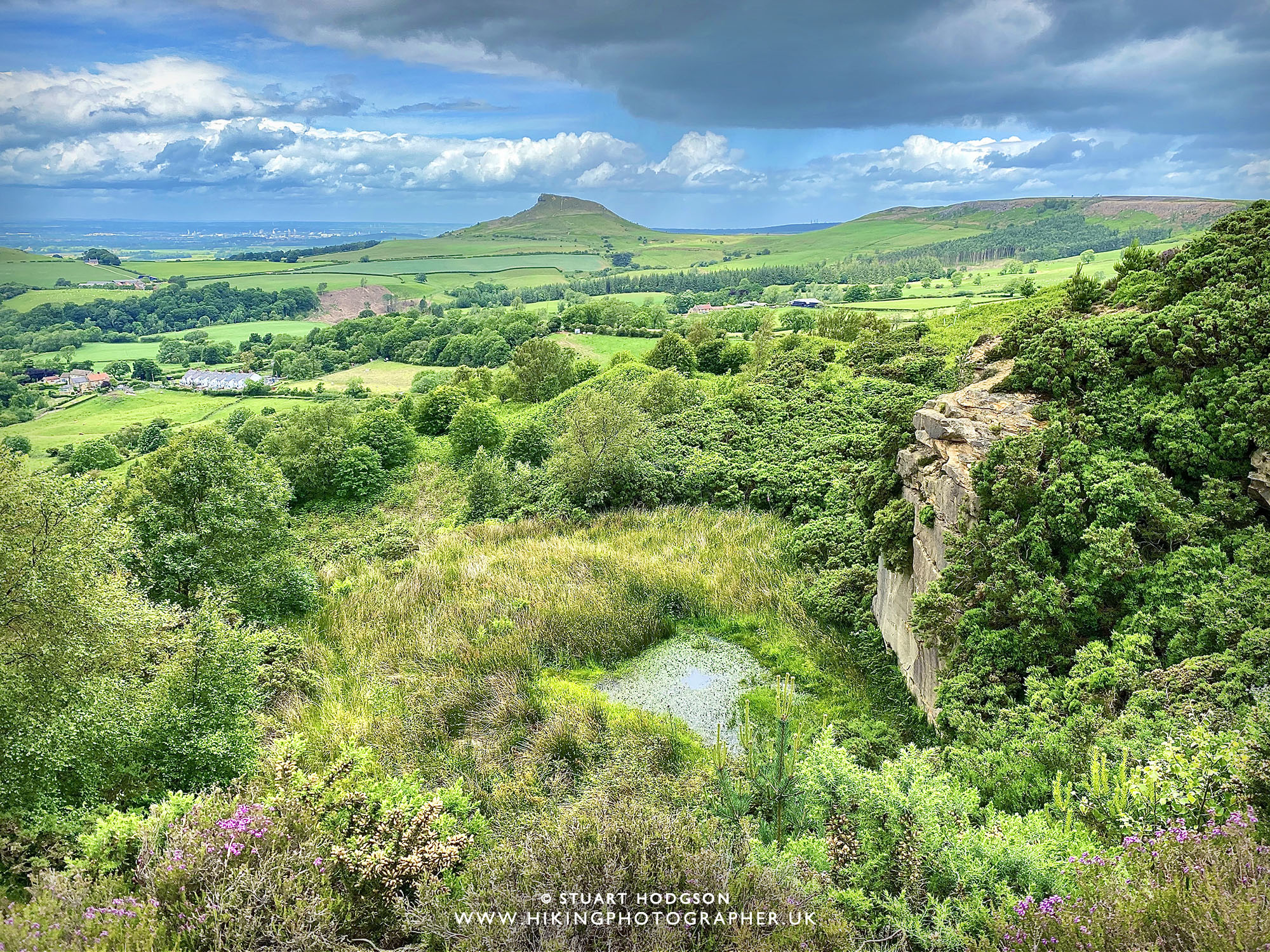
| This view is probably my favourite view of Roseberry Topping in the whole area. It's taken from just above the old quarry on Cockshaw Hill and isn't far from Captain Cooks monument, but is a little off the the main walk path to Captain Cooks monument. |
Life Insurance
Roseberry Topping walk via Captain Cooks Monument & Cockshaw Hill overview:
Roseberry Topping Walk Distance: 7 miles
Roseberry Topping Walk Time: 3.5 hours
Roseberry Topping Walk Difficulty: Moderate
 |
| If you've got time on your hands this 7 mile Roseberry Topping walk starts in Great Ayton and my prefered way is in a clockwise direction to Roseberry Topping first via Newton Wood (May is the ideal time to visit Newton Wood for the Bluebells) and then you get on the Cleveland Way and head south for Captain Cooks Monument. As the walk approaches captain Cooks Monument it takes a little 5 min detour to the side of Cockshaw Hill to see my favourite view of Roseberry Topping just above the old quarry (you can miss this out of you like) Once at Captain Cooks monument you then head back to Great Ayton via Ayton Banks wood. This is a long route with multiple paths junctions and I really recommend viewing the full interactive OS Map route via the button below and downloading it to keep you on track (subscription required for all features) |
If you don't have a Phone Map App - I really recommend the one by Ordnance Survey. You can download route maps to your phone such as this one and the app will show you exactly where you are on the route even when you have no signal - so no more taking a wrong turn :-)
 |
| This longer Roseberry Topping walk takes you through Newton Wood and if you do it in May time the Bluebells will be in full bloom |
 |
| There are 3 main paths up to the summit of Roseberry Topping (from the North, East & South) On this walk you will tackle Roseberry Topping from the southern end. |
 |
| The views from the summit of Roseberry Topping are superb in all directions. In this photo you can see the route we will take along the Cleveland Way from the path on the left of the pic - all along the brow of the hill to Captain Cooks Monument on the far right (which you can just about make out above the tree covered slopes of Ayton Bank!) |
|
| On this walk route I've added a little 5 min detour to the viewpoint at Cockshaw Hill which is just near Captain Cooks monument and offers my favourite view of Roseberry Topping in the area. If you visit at the end of August/September the pink heather will be in full bloom. (You don't necessarily have to do this longer walk route to visit this stunning viewpoint and you can just park at Gribdale Gate and walk 10 mins to it and then onto Captain Cooks monument) |
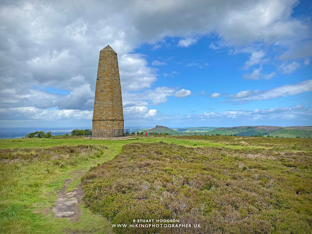 |
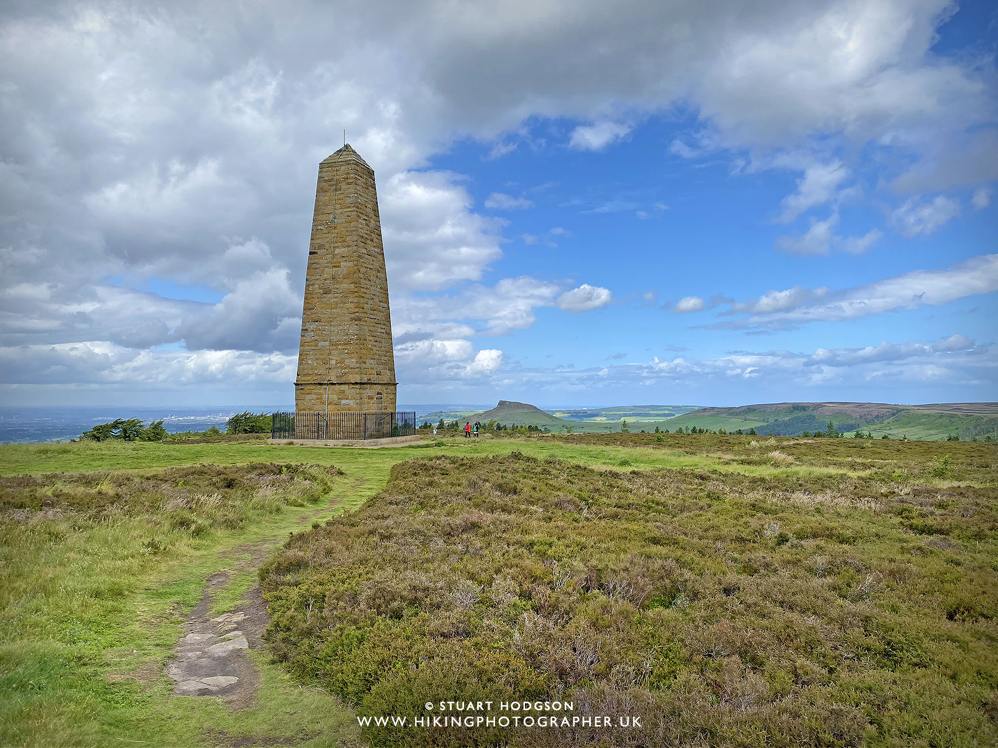
| Captain Cooks monument makes a good point of interest to walk too along the Cleveland Way from Roseberry Topping and the views are pretty impressive up here too! Once up here you then have a nice walk back down to Great Ayton via Ayton Banks Wood. |
And there you go - that's my 3 best Roseberry Topping walks. They are all of varying distances and there is something for everyone there. I live in the area and I never tire of the views around this fantastic countryside. I often walk all over Northern England to the Lake District, Yorkshire & Northumberland - but return time and again to this lovely part of North-Yorkshire and its my go-to local area for walks. I hope the blog post helps you in planning a visit to the Roseberry Topping area!
Post by Stuart Hodgson
'The Hiking Photographer'
Subscribe to my monthly email newsletter to stay up to date with all my outdoor adventures, including my latest photos & walking blog posts, as well as a whole host of tips & interesting stuff for outdoor enthusiasts, just click the link below to subscribe.
FOLLOW ME
Not all my adventures & photos end up on this blog -
Give me a follow to see what else I've been up to!
LIFE INSURANCE QUOTE
WORK PLUG:
Here are some other things I'm involved in - please support if you can :-)
Life Insurance policy how much


Enjoyed reading your walks - thank you. We are coming to the north-east next week and are looking forward to exploring the area. Is there a free equivalent to the OS maps app - or is that too much to hope for!.
ReplyDeleteHi - glad you find the blog useful. There are alternative apps - but if you wish to use the OS Maps within them then there's a licensing cost associated. All Trails is ok - they have different types of maps (but not as detailed). I've tried a few tbh - and settled on the OS Maps App as the best - for the amount of times I use it - it's great value. Hope you enjoy exploring the area!
DeleteFound this website, signed up for the mailing list, downloaded the OS maps app, harnessed up the dogs and completed this walk in reverse (randomly). I’m hooked. Great walks with great images. Looking forward to my next walk with the 🐕 🐕
ReplyDeleteHi Nick - chuffed you have found this blog post useful and you enjoyed your walk. Hope you do many more walks - cant beat a good dose of the outdoors!
Delete