 |
| The summit of Place Fell looking east towards Pooley Bridge and the Pennines beyond |
The superb Place Fell circular walk with stunning Lake District views
Place Fell is a modest Lake District peak with stunning views in all directions and is an excellent walk to do in the Ullswater area. I really recommend the circular routes on this page as the walk is varied, including a nice section along the shores of Ullswater. More often than not the walk is done from Patterdale - however it's quicker for me to drive to Sandwick (I live to the east of the Lakes) so that's the place I start from. I always recommend doing the steeper uphill section first to summit Place Fell, wherever you start form, returning on a more flatter route along Ullswater's edge.
 |
| Below are the 2 best Place Fell wlaking routes in my humble opinion from 2 different starting points - Patterdale & Sandwick |
Place Fell circular walk from Patterdale, map route:
Place Fell Walk Distance: 7.7 miles
Time: 4.5 hours
 |
| The most popular route to Place Fell is from Patterdale, in an anti-clockwise direction, with the steep ascent at the start to the summit and then a more leisurely return via Ullswater's edge. |
Place Fell circular walk from Sandwick map route:
Place Fell Walk Distance: 7.5 miles
Time: 4 hours
 |
| An alternative place to start is from Sandwick in the east. Where you'll find space to park a handful of cars. The paths aren't the clearest on some sections, and there are a few paths that cross each other, so a Phone Map app is always useful! |
If you don't have a Phone Map App - I really recommend downloading OSMaps by Ordnance Survey. You can download route maps to your phone such as this one and the app will show you exactly where you are on the route even when you have no signal - I'd be lost without it (literally :-) It's also great for planning walks and even viewing routes in 3D! Click the link below to find out more.
 |
| Here's a 3D view of the walk route from Sandwick that I took from OS Maps, and you can clearly see the sort of terrain on the route - what a nifty little online tool! Certainly stops you from under-estimating walking routes on flat maps haha |
 |
| And here's a more overhead view of the route to show how the walk loops around the edge of Ullswater on a flatter section once you have summited Place Fell |
Photos of what to expect from this Place Fell walk route from Sandwick
 |
| We begin todays walk with a gentle uphill towards High Knott - and we can make out Bleaberry Knott to the right. While it's sunny it's a little chilly in the shade! |
 |
| Taking a pit-stop to admire the Ullswater views on this perfect morning for a walk. You can just make out Hallin Fell to the right here with the Pennines in the far distance. The forecast wasn't great for todays walk but the start of the walk was better than expected. |
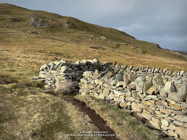 |
| We arrive at Low Moss which represents a bit of a junction for a few routes to Place Fell - we check the map and head in a straight direction towards Place Fell to the left of this photo. There is another path which takes diagonal to the top right of the photo, but I recommend heading straight for Hart Crag & Place Fell a step path is clearer. |
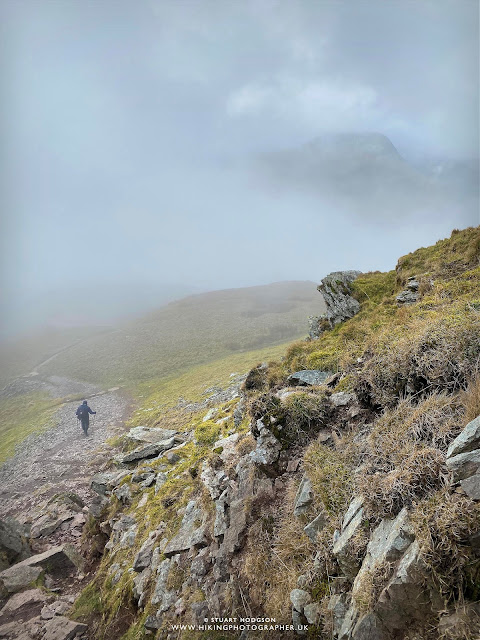
The mist soon roles in and the views aren't great - quite a turn around from only half an hour ago! But we plod on and can just about make out the summit Cairn of Place Fell and we know we are heading in the right direction.
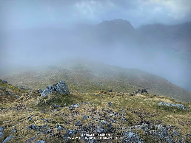 |
| The views form Place Fell are stunning all around (you've got to believe me here haha) - but not so much when we first arrive at the summit. The skies are nice and dramatic though. |
 |
| And just like that the mist starts to clears a little just as we arrive at the summit of Place Fell |
 |
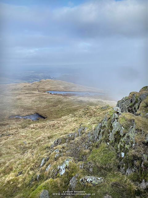
| Fortunately once at the summit we get some decent, yet fleeting, views of the surrounding area. Here is the summit of Place Fell looking east towards Pooley Bridge and the Pennines beyond |
 |
| The Place Fell summit :-) And it makes a good place to take a rest and shelter out of the wind. |
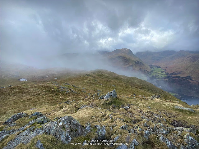 |
| The mist clears again a little on the summit and here we are looking west towards Glenridding and the Helvellyn range beyond (that is shrouded in cloud & mist :-) |
 |
| It's a blustery day today and the mist rolls in and out in seconds - very dramatic how one moment you can't see anything - and then all is revealed! I love hiking in these conditions (they just don't make for the best of views :-) |
 |
| Time to head back down from Place Fell and walk towards Boredale Hause. A phone map app (and compass) is really handy in these misty conditions when you have no recognisable landmarks to help choose direction |
 |
| Its initially quite a steep decent from Place Fell - and use of hands is required in small parts - but it's nothing too tricky and is a great little walk for people of all ages. |
 |
| We then catch glimpse of Ullswater again looking over towards Patterdale & Glenridding. |
 |
| A moody Ullswater - and these Lake District landscapes look amazing whatever the weather |
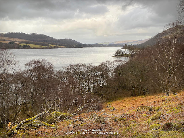 |
| We follow the shores of Ullswater for the return leg of this Place Fell walk on a path that is raised from the lakes edge and it's a lot more flatter and leisurely, but gives some excellent views all the way back! |
And that wraps up this Place Fell walk near Ullswater. As mentioned there are two starting points for this walk depending on which you prefer and suits you and I hope this little post inspires you to try out this route to summit the excellent Place Fell, one of the best walks in the Ullswater area.
Happy Hiking!
Post by Stuart Hodgson
'The Hiking Photographer'
Subscribe to my monthly email newsletter to stay up to date with all my outdoor adventures, including my latest photos & walking blog posts, as well as a whole host of tips & interesting stuff for outdoor enthusiasts, just click the link below to subscribe.
FOLLOW ME
Not all my adventures & photos end up on this blog -
Give me a follow to see what else I've been up to!


"We then catch glimpse of Ullswater again looking over towards Patterdale & Glenridding." Wow! That's been done up. I remember walking that track when it was a stream due to the continuing rain, after camping up top overnight and getting washed off the fells.
ReplyDelete