

You’ll see this superb view on this York City Walls walk. Read on to learn more about this excellent short walk
YORK CITY WALLS WALK – A must-do activity for any visitor to York
York is a historic walled city in England with a long and rich heritage from Roman times through to Viking times and beyond, and for any tourist to York – a walk around the brilliantly preserved and ancient medieval City Walls is a must and will let you see York from a vantage point that not many tourists do.
York has more intact historic walls than any other city in England, and at 2.6 miles long they are the longest medieval walls in England.
 |
|
Tip: Take some slight detours to come off the York City Walls to view the various ‘Bars’ or ‘Gatehouses’ from the street in all their glory. In ancient times these ‘Bars’ where used to restrict entrance into the city and extract tolls. |
York City Walls: A Walk Through History
If you fancy a York walk with a bit of history thrown in, you can’t go wrong with the York City Walls. Wrapping around the heart of the city, these medieval walls are the longest in England, and they’ve been standing for well over 2,000 years in some form or another. You’ll get stunning views of York Minster, hidden snickets, and a real feel for the city’s past as you stroll along. Best of all? It’s completely free!
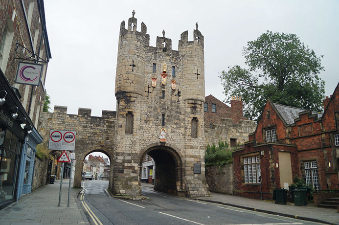
The York City Walls walk stretches for about 2 miles, with plenty of spots to hop on and off if you fancy a break. They were originally built by the Romans, but most of what you see today dates back to the 13th and 14th centuries. There are four main ‘bars’ (big old gatehouses) along the way—Micklegate Bar being the most famous. It was once where the severed heads of traitors were displayed, which is a bit grim, but hey, history wasn’t always pretty!
One of the best sections of the walk is near Bootham Bar, where you get a cracking view of York Minster towering over the city. Another highlight is the stretch near Monk Bar, which has a tiny museum dedicated to Richard III—well worth a peek if you like your medieval kings. The walls are surprisingly well-preserved, with plenty of spots to stop, soak in the view, and imagine what life was like back in the day. Just watch your step, though—some of those ancient stones are a bit uneven!
Whether you’re a history buff or just fancy a scenic wander, the York City Walls walk is one of the best things to do in the city. It’s got a bit of everything—gorgeous views, medieval history, and a great way to get your bearings around York. So, lace up your comfy shoes, grab a coffee from one of the city’s brilliant cafés, and set off on a walk through the past. You won’t regret it!
What are the York City Walls?
The York City Walls are a series of medieval walls that once enclosed the city of York, England. Built over several centuries, these walls were primarily constructed for defense purposes but also served as a symbol of the city’s power and importance. The walls are one of the most complete examples of city walls in England, stretching for about 2 miles (3.2 km) around the historic city center. Today, they are a popular tourist attraction, offering scenic views of the city and a glimpse into York’s rich history.
How long is the York City Walls walk?
The full walk around York City Walls is approximately 2 miles (3.2 kilometers) long. It takes about 1 to 1.5 hours to walk the entire route, though you can take your time and enjoy the views, stopping at the various gates, towers, and historic landmarks along the way.
Can you walk York City walls for free?
Yes, York’s City Walls can be walked on foot, for free, throughout the year. York’s historic city walls are a major feature of this historic city and give excellent views.
What are the main gates of York City Walls?
The York City Walls have several main gates, known as “bars,” which provided entry to the city in medieval times. The four most famous gates are:
- Bootham Bar (north of the city, near the Minster)
- Micklegate Bar (the main southern entrance)
- Walmgate Bar (on the east side of the city)
- Monk Bar (to the north, near the York Castle Museum)
These gates are historically significant and many of them still have original features, such as fortified structures and impressive archways.
How long does it take to walk around York City walls?
Alow 1.5-2 hours to walk the full The York city walls circular route. The walk is 2.6 miles in distance, which occasionally descends back to street level.
Where do the York City walls walk start?
As the York City Walls walk is circular you can start anywhere that is closest to you. I do recommend getting up onto the walls at one of the ancient and still-entact ‘Bars’ or ‘Gatehouses’ as shown on the map on this page as this is a more impressive approach. My recommended starting point is ‘Bootham Bar’ – which is close to York Minister and will instantly give you some stunning views (see map below), you can of course start your circular walk at at point on the map really!
York City Walls Walk route map:
 |
| [Click to enlarge] I think this is the clearest map of York City Walls to show you the full walk route and the parts you actually walk on the walls and where you should walk at ground level where there is no wall still standing. The best place to start I think is from the ancient gatehouse called ‘Bootham Bar’ slightly to the west of York Minister (the blue dot next to the number 1 in the above map) – where you will walk up onto the York City Walls at Bootham Bar and then walk around the walls in a clockwise direction. By starting here you will instantly get really upclose to York Minister with some of the best views on this walk. Whilst I didn’t actually use the audio tracks also featured on the above map – it could be useful for those wanting a bit more history of the walls – see http://www.tourist-tracks.com/tours/york.html |
York City Walls DEFENCES & GATEHOUSES:
 |
| [Click to enlarge] This map clearly shows all the particular defences and gatehouses along the York City Walls and I will cross-reference where I can in my photos below |
 |
| Keep reading for tips and photos of this York City Walls walk. |
York City Walls walk photos of what to expect:
Here’s some photos I took on my walk around York’s City Walls to give you a flavour of what to expect!
 |
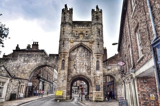
| So this is where I started my York City Walls walk at Bootham Bar (the city walls have four main gatehouses or ‘Bars’ along them – Bootham Bar, Monk Bar, Walmgate Bar and Micklegate Bar. In this photo you can just make out York Minister behind the wall, and you will soon see we get quite close to York Minister at the start of this walk once you climb up the steps and onto the wall. |
|
|
| The footpath along the York City Walls is quite wide and flat and you feel very safe with the railings on the high parts (ideal if you are doing this York City Walls walk with young children) |

 |
| The first and one of many views of York Minister on this section of the York City Wall route |
 |
| Looking back along the first section of the York City Wall we have just walked |
|
|
| Many properties have back gardens leading onto the York City Walls so you get views that you wouldn’t normally see from the streets in York |

 |
| This particular place is called Robin Hood’s Tower and is good for a little stop |
 |
| Approaching Monk Bar and up close the roof tops here! |
 |
| Tip: Take a detour to come off the city walls for a bit to view Monk Bar in all it’s glory from road level, then just get back on the wall! |
 |
| We’re really up close to the rooftops again! |
 |
| It’s a great walk to see York from a vantage point that not many visitors do! |
 |
| York City Walls are quite intact on many parts of it |
|
|
| So you can’t walk on the York City Walls around the full circular route. At this section we drop down from the walls at Laythorpe tower – you have to walk along Foss Island Road (keeping the river Foss on your right) until you get to the Red Tower. The reason there is no wall here is because originally this area of land was flooded and formed the ‘Kings Fishpond’ – a more natural form of York’s ancient defences – so walls weren’t needed here! |
 |
| Keep an eye on the signs on this road section – they are sometimes not the in the clearest eye shot! |
 |
| Now we are at Red Tower and we get back onto the York City Walls! |
 |
| You probably won’t bump into many people on this section of the York City Walls |
 |
| At this section we are approaching Fishergate Bar |
|
|
| When you come down off the walls at Fishergate Bar – you leave the walls for a little while. You need to keep the Travel Lodge on your right and walk along Tower Street and straight over the bridge over the river Foss. |

|
|
| Whilst we take a detour from the walls as there is currently none to walk on – we head over to take a look at York Castle or Cliffords Tower – which was built originally in 1068 by the orders of William I to try and dominate these Viking lands. As you can see from the brooding clouds a rain shower was on it’s way so it was time to take cover! |

 |
| Crossing over the River Ouse once the rain shower had passed |
 |
| Getting back up onto the Walls at the first opportunity at Skeldergate access tower |
 |
| The York City Walls are a good way to get somewhere and avoid the crowds too! |
 |
| The view from Micklegate Bar |
 |
| Tip: Come down off the walls again to see the full view of Micklegate Bar |
 |
| Once back up on the city walls – the wall walk now takes us past York Railway station on the left |
|
|
| One of the best views on the York City Wall walk as the wall leads you eye all the way to York Minister in the distance. This spot is a very popular spot for photographers wanting that quintessential photo of York – and if you do this walk – get your own photo here 🙂 |

 |
| This seems to be the busiest part of the wall too. I often hop onto it here from the train station and walk the walls into the city centre |
 |
| Heading back to the York Minister area |
 |
| I’ll really recommend this section of the York City walls if you ever arrive in York by train – to beat the crowds and traffic! |
|
|
| Now we are approaching the end of the opportunity to walk along the city walls at North Street Postern before we get to the River Ouse again. You can see Barker Tower to the right and Lendal Tower at the other end of the bridge. Once over the bridge you can go and get a well deserved drink in one of the many coffee shops and pubs/bars – or enter the Museum Gardens near where you started the walk and take a look at the Multangular Tower. |

|
|
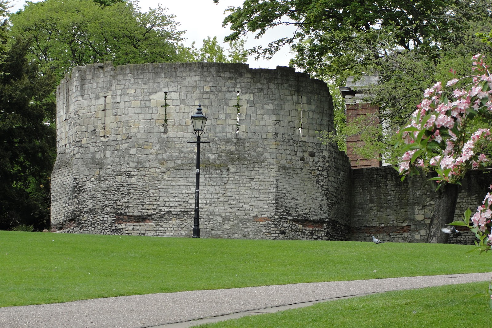
| Tip: Take some time out to view the Multangular Tower in the museum gardens – the best example of standing Roman remains in York – which probably date from the early third century. |
So there you go – quite a few photos of what to expect on a walk around the historic York City Walls and some of my best views of York. I hope the blog post helps you to want to take a tour of the York City Walls (its only 2.6 miles and can be done in just over an hour 🙂 and discover a little more about one of my favourite cities in England.
YORK CITY WALLS – INTERESTING FACTS
Here are some lesser-known facts about York City Walls that might surprise you:
1. They Contain Hidden Roman Stonework
While most of the walls we see today date from medieval times, if you look closely, you can still spot some Roman stonework in places. The original Roman walls were built around 71 AD, and sections of these ancient defenses were later reused by the Normans and medieval builders. One of the best places to see this is near the Multangular Tower in the Museum Gardens.
2. There Was Once a Moat surrounding York city walls!
Back in the day, York City Walls were surrounded by a deep moat, particularly around Fishergate. This wasn’t just for defense—medieval moats often doubled as sewage disposal areas (not the prettiest thought). Over time, the moat was filled in, and today, a lot of that land has been built over.
3. The Walls Were Nearly Destroyed in the 19th Century
Believe it or not, there was a plan to demolish York City Walls in the 1800s! Some officials thought they were outdated and unnecessary, and parts of the walls were even knocked down. Thankfully, a public outcry saved them, and restoration efforts in the late 19th and early 20th centuries helped preserve what we see today.
4. There’s a ‘Missing’ Section at Layerthorpe
If you ever follow the York City Walls walk, you might notice that there’s a big chunk missing near Layerthorpe. This isn’t due to damage in battle but because, in the 19th century, they were removed to make way for modern roads and railways. There have been discussions about restoring this lost section, but so far, the gap remains.
5. Micklegate Bar Was Once a Royal Entrance
Micklegate Bar, one of the grandest gates in the walls, was where royalty entered York. Kings and queens had to ask permission from the Lord Mayor before they could pass through. However, it was also the place where the heads of traitors were displayed on spikes—grim but true!
So when you’re walking the York City Walls, keep an eye out for these hidden details. There’s a lot more to them than meets the eye!


0 Comments