

The Yorkshire 3 Peaks challenge is an excellent challenge for serious walkers and I’d definitely recommend it if you’ve thought about doing the walk. It’s a long hike of 25 miles and I have some tips and useful bits of info that I’ve learned from doing the Yorkshire 3 peaks that I wish I knew and I thought I’d share below to help you plan your own Yorkshire 3 Peaks walk.
Yorkshire Three Peaks Challenge walk – essential information & tips
 |
| Read on for the common Yorkshire 3 Peaks questions answered and my essential tips to help you plan well for your walk |
Yorkshire 3 Peaks – common questions:
HOW LONG DOES IT TAKE TO WALK THE 3 PEAKS IN YORKSHIRE?
he popular challenge is to walk the Yorkshire 3 Peaks in under 12 hours. Most experienced walkers with good fitness should be able to do it in 10-12 hours. When I did it we weren’t walking exceptionally fast – just normal pace with maybe 4/5 10 min stops and it took us 9 hours and 40 minutes.
HOW FAR IS THE 3 PEAKS IN YORKSHIRE?
The Yorkshire Three Peaks is 25 miles on the best, most popular walking route, as shown on the map below.
IS THE YORKSHIRE 3 PEAKS HARD?
The Yorkshire 3 Peaks is not to be taken lightly – you’ll be walking a marathon distance for around 12 hours and the combined ascent is more than 1,800m, which is greater than Ben Nevis, the UK’s tallest mountain at 1,345m.
WHICH OF THE YORKSHIRE 3 PEAKS IS THE HARDEST?
Pen-Y-Ghent (694m) is the steepest peak if you walk it from the south and you’ll need to use your hands and scramble (I found this the hardest). Whernside is the tallest at 736m but it seemed the easiest if you go up the more gentler path from the east and I’d say Ingleborough (723m) was the second toughest. It can be subjective though – and perhaps for many the hardest is the last peak they do 🙂
 |
| Pen-Y-Ghent above is the smallest in height of the 3 Peaks – but the most challenging to ascend if you go up the steepest side. It’s best walked up on the steepest south side (pictured right above) and walk down the more gradual way. |
Yorkshire Three Peaks – lessons to share from my walking challenge:
What direction should you walk the Yorkshire Three Peaks?
THE BEST YORKSHIRE 3 PEAKS ROUTE:
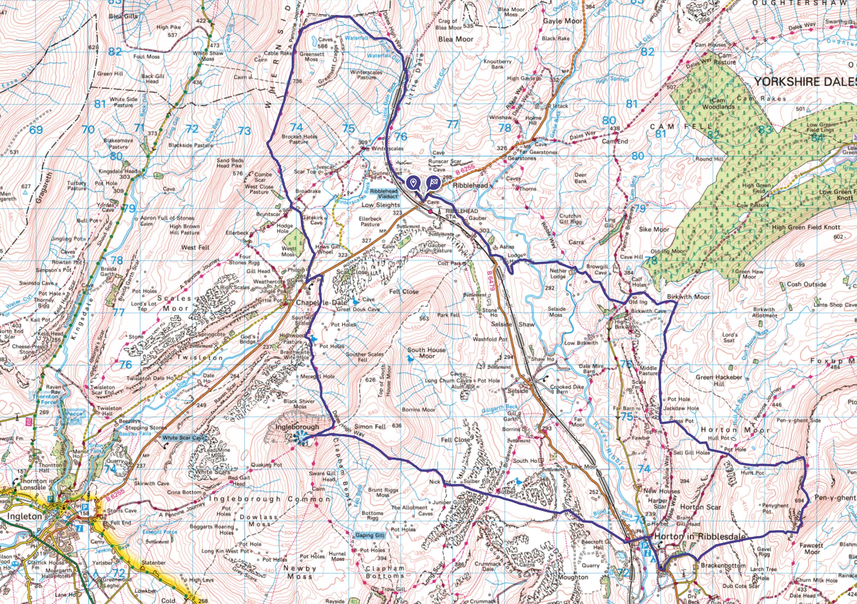 |
| Here’s the best Yorkshire Three Peaks walk route on the map in my humble opinion, which everyone can use no matter your starting point. As mentioned I do recommend walking in an anti-clockwise direction, to tackle the peaks in the best direction to go up/down them and in my opinion Ribblehead Viaduct is the best place to start (plenty of parking there) and then head up Whernside as the first Yorkshire 3 Peak, then onto Ingleborough then Pen-Y-Gent last. [You can click the map image to enlarge/save, or click the buttons below to view the interactive OS Map route or download the GPX route. My phone map app of choice is the OS Maps App and it’s worth subscribing too for your Yorkshire 3 Peaks challange] |
WALK OVERVIEW:
WALK DISTANCE: 25 miles
WALK TIME: 10+ hours
WALK DIFFICULTY: HARD

OS Maps - my Recommended App
I've tried a few map apps on my phone and settled on OS Maps, to access detailed UK Mapping. You can plan, save and download mapo routes, such as those on this site, direct to your phone, and then see where you are exactly on any route even when you have no signal - so you can't get lost! It's helped me discover loads of new walking routes too and you can get a free 2 week trial via the button below.
Where should you start your Yorkshire Three Peaks walk?
 |
| There is plenty of free car parking spaces on the roadside around Ribblehead Viaduct, like the section pictured above, – which makes for a good place to start the Yorkshire Three Peaks walk |
When is the best time to do the Yorkshire Three Peaks?
How much water should you take on the Yorkshire Three Peaks challenge?
What toilets are there en-route on the Yorkshire Three Peaks?
 |
| Philpin farm barn – one of the most essential stops on route and where topping up water is easiest and there’s also toilets here. This is probably the place which is most welcoming for Yorkshire Three Peaks walkers and is guaranteed to be open no matter what. |
 |
| As you can see Philpin Barn is rustic – but a much welcome stop on the Yorkshire Three Peaks walk. Here you will find a drinking tap for water bottle filling (pictured inset near the door), toilets and a vending machine selling snacks & hot drinks (taking card payments). If the weather is not the best it’s also a great place to take shelter. |
What food should you take on the Yorkshire Three Peaks Challenge walk?
I’d recommend taking all your food with you. There are places you could buy food from (same places where you could refill your water) but don’t rely on them. Your food is your fuel for the day, so high-carbs is the name of the game. Have a high-carb tea the night before (eg.pasta), a good breakfast (porridge etc). Also use the travel time to the start of the walk to get some good energy onboard. To take on demanding walks I personally like peanut-butter bagels, bananas, sandwiches, cereal bars, jaffa cakes, nuts, chocolate bars as a treat, and it’s also a good idea to take a bag of sweets (jelly babies, fruit pastilles etc) for mini-treats and instant energy at the bottom of each peak, as well as energy gels etc.
What footwear should you wear on the Yorkshire Three Peaks Challenge walk?
First and foremost wear footwear that you have walked in before over many miles and are broken in. The Yorkshire Three Peaks is not a walk to try out brand new footwear (or footwear you’ve only used a couple of times) or you will end up with blisters which will make your walk much more difficult and painful. It can be done in Trail running type shoes as the path is well marked most of the walk and either gravel or stone slabs. Waterproof footwear is a must though if rain is forecast. One of my best tips: Take 1 or 2 extra pairs of socks and change them on or just after each peak. Your feet will sweat on this long walk, making your socks damp and moisture makes blisters more likely to form – so try and keep your feet dry. Even give your feet a bit of fresh air when you stop if the weather is good. One of our group had only done a couple of walks in their new footwear and ended up with the worst blisters I had seen – he some hoe powered on though. Someone else in our group forgot their walking boots lol – but managed it in trainers (which weren’t in the best of states by the end of it 🙂
What clothes shall I take on the Yorkshire Three Peaks?
Other recommended items to take when doing the the Yorkshire Three Peaks Challenge walk?
- Walking poles may come in handy for the summit descents, especially if your knee’s aren’t what they used to be!
- Plasters might come in handy as blisters are a common occurrence over 25 miles of walking.
- Take a head-torch if you are doing this walk at the time of year when days are shorter – just incase it takes longer than you think or there’s any injuries or sudden mobility issues.
- You’ll be on the walk for 10-14 hours – and a phone battery power bank might help keep your phone in use (important if you are using your phone for directions – bare in mind the signal is poor or non-existent on a lot of the walk)
- Route Maps – to keep you on the right track – make sure you have the Yorkshire 3 Peaks route downloaded to your smart watch or phone (to work without phone/internet signal as you won’t get signal on much of this route) Also take a paper map as a back up as you never know! The paths are pretty clear though.
How much training should you do for the Yorkshire Three Peaks?
photos of our Yorkshire 3 Peaks challenge
DATE OF WALK: May 13th 2022
TIME TAKEN: 9 hours 40 mins
 |
| Here is our gang – all 10 of us and some carrying a bit of extra weight (and I’m not talking about the bags haha). Read on below to see some phtos of our Yorkshire Three peaks challenge which might give you a flavour of what to expect! |
Y3P – Ribblehead to Whernside:
 |
| The date of our Yorkshire Three Peaks walking challenge was Friday 13th May. Not the best omen haha – and as you can see the weather was pretty rubbish at the start at Ribblehead Viaduct with fine drizzle. Fortunately it wasn’t tanking down with rain, but very windy and poor visibility. We started at 8am and the forecast was to dry out later so that was enough to keep spirits up knowing we weren’t in for a full day of rain and wind on this 25 mile walk. |
 |
| Although Whernside was our first peak to walk too (and the highest) we felt the ascent from the east was pretty easy going, with clear footpaths and not very steep on the way up. This is one of the reasons I recommend doing the Yorkshire Three Peaks walk in an anti-clockwise direction. It’s just a shame the visibility was bad. |
 |
| Stunning views from Whernside summit lol – the first of our Yorkshire Three Peaks. It was very windy on our walk – gales at times and the dry stone walls did give us useful shelter to have a snack and refuel. |
Y3P – Whernside to Ingleborough:
 |
| Heading back down from Whernside, with the next Yorkshire Three Peak of Ingleborough in the far distance and again covered in cloud. We did find the going between each of the Peaks relatively flat once you are at the base of the Peaks. |
 |
| Looking back up at Whernside, the summit now with good visbility – typical eh! It was quite steep coming down from Whernside – and we did pass people going up this way, and I’m glad we went up and down the way we did. |
|
| The route inbetween Whernside and Ingelborough goes by Philpin Farm and their Barn is the best place on the entire route to fill water bottles from their tap, use the toilet and you can also get snacks & a hot-drink from the vending machine. It’s very welcoming towards Yorkshire Three Peak walkers and there isn’t many places to stop on the entire route so make the most of this place 🙂 |
 |
| One Yorkshire Peak down and now onto the next one! |
 |
| We now make our way to Ingleborough and the going is flat for a while to get warmed up again after our stop. The path up to Ingleborough heads to the left of the main summit towards the far left of this pic and you then take a sharp right at the top of the dip towards the higher summit plateau. |
 |
| Approaching the 2nd Yorkshire Three Peak of Ingleborough. Before the walk I did wonder about the paths and what they would be like, and I did read some places where boggy. Maybe there’s been work on the paths throughout the entire route but all paths where well marked and at no point did we go through boggy places on this route, and on the occasion the ground was a bit soft – either wooden walkways or gravel path had been laid. |
 |
| The ascent of Ingleborough – this section zig zags up as it’s quite steep – so you’ll probs want to take a few stops to “admire the views” |
 |
| The summit top of Ingelborough is quite expansive and very open to the elements. What this photo doesn’t show is the very windy conditions which was right in our faces. |
 |
| The summit of Ingelborough and our 2nd of the Yorkshire Three Peaks. It’s very open and exposed up here so can be windy. There is a little stone wall shelter for maybe 20 people, but if it’s busy and windy you might just have to bag the summit and take a rest on the descent. |
Y3P – Ingleborough to Pen-y-Ghent:
 |
| Onwards we walk to Horton-in-Ribblesdale, with Pen-Y-Ghent in the far distance |
 |
| As you can see the footpaths are well maintained and clear and at times it’s like walking on the pavement and you feel like your cheating – but you’ll be glad of it to make the 25 miles walk a bit more easy going |
 |
| There’s quite a few signs about to keep you on track – as pointed out here by Mossy. What this photo doesn’t show with Mossy – is his footwear. He actually forgot his walking boots – so had to do it in the trainers he travelled in – and to be honest he got away with it – due to the paths being well defined on the full route! |
 |
| The distinctive summit of Pen-Y-Ghent is straight ahead and visible all the way from Ingleborough |
 |
| The walk leads us next to Horton-in-Ribblesdale |
 |
| Horton-in-Ribblesdale is where many start the Yorkshire Three Peaks walk from, and I hadn’t been before, To be honest I expected it to be a bigger village than it is and more facilities for the Yorkshire Three Peak walkers (I’d imagine on special charity events there are more temporary facilities here?). You’ll find public toilets here, but nothing much else. The famed Pen-Y-Ghent cafe is closed [May 2022], there is a small shop/post-office (but this was also closed on the Friday we where there so I wouldn’t rely on it). The best place to refuel or grab a drink would be the local pub. |
 |
| Onwards to Pen-Y-Ghent- the third and final of our Yorkshire Three Peaks. We’ll walk up the steep section (pictured right) and descend the more gradual route on the left. |
 |
| This route up to the summit of Pen-Y-Ghent is the steepest section on the entire Yorkshire Three Peaks route |
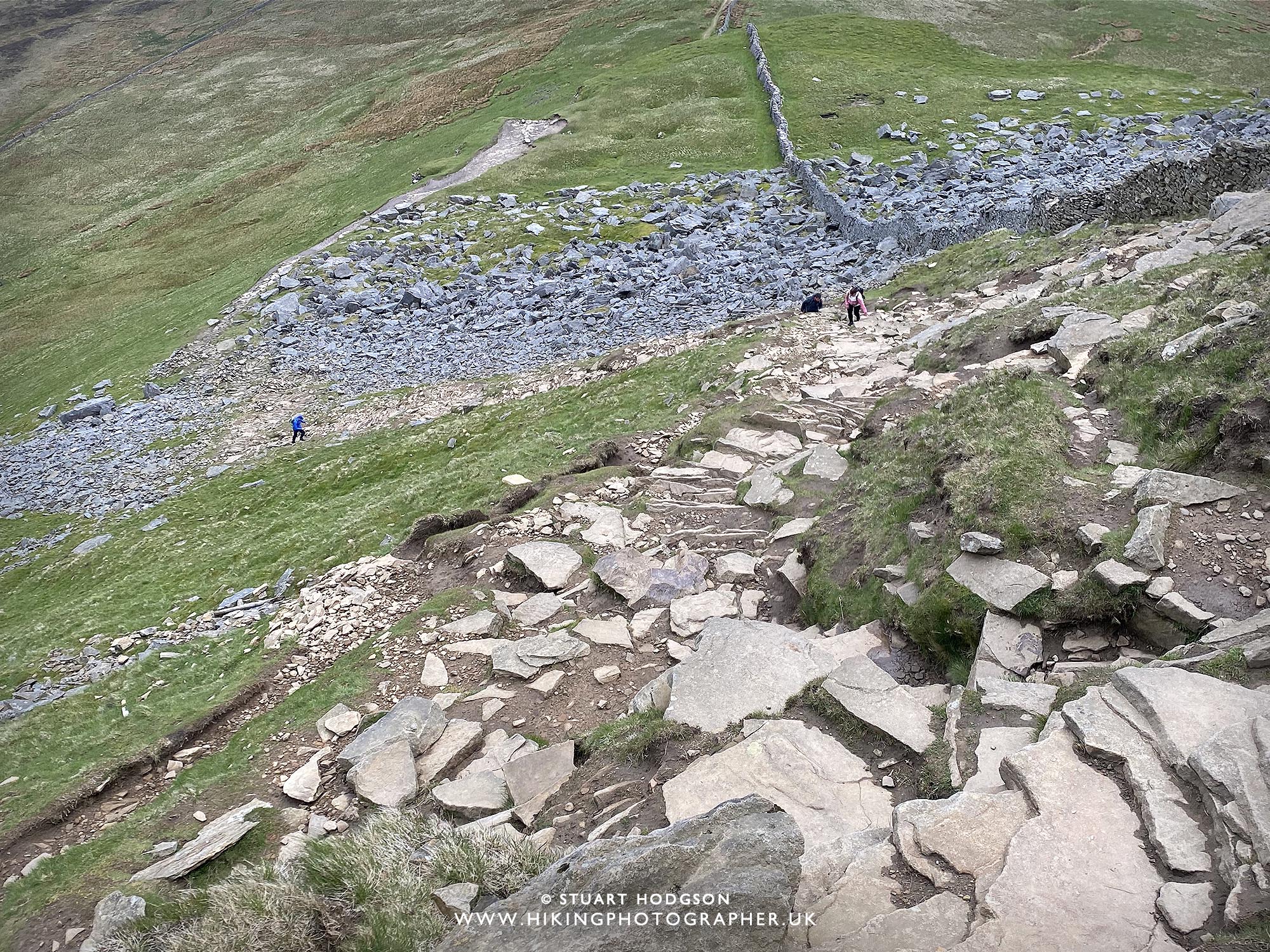 |
| You’ll need to scramble in sections and use your hands. If you don’t like steep and exposed walks you may want to modify the route and ascend and descend up the more gradual northern Pen-Y-Ghent path. Although my leg muscles where pretty shot after this steep section – it was a good challenge and we got to the summit in no time |
 |
| The Pen-Y-Ghent summit – we could actually see from the top of our third and final Yorkshire Three Peaks summit haha. There is a stone shelter and wall up here and it’s a good place to stop, refuel and be happy there’s no more uphill sections 🙂 |
Y3P – Pen-y-Ghent to Ribblehead:
 |
| The descent of Pen-Y-Ghent is much more gradual this way and we’ve got about 7 miles left to go that is pretty easy going. Strangely enough just after summiting Pen-Y-Ghent that’s when I had my little dip in energy – I think I got complacent and thought I’d completed it on the 3rd Peak summit – then realised there was still a bit of distance and graft to do in the leg muscles on the descent! Once down to base level I got my mo-jo back lol |
|
|
Looking back at Pen-Y-Ghent on this Yorkshire Three Peaks walking challenge
|
 |
| The going back to Ribblehead is pretty flat, just as well as the legs are now tired! One member of the group got cramp about here. The summit of Whernside is just visible in the far distance here and you realise there is still a bit of distance to go, but the group banter & chat helps keep spirits up and pass the time. I think doing this walk on your own would be much more of a challenge mentally and I’m def glad there was a few of us doing it |
 |
| The last section of this route is on the roadside for about 30 mins and spirits are high that we have nearly completed the Yorkshire Three Peaks walking challenge. |
 |
| Boom! What a sight for sore eyes! The Ribblehead viaduct – which means we have done it. We completed The Yorkshire Three Peaks walking challenge in 9 hours and 40 minutes. Much better than we hoped tbh. We aimed for under 12 hours – and thought at best we’d do it in 11 or 10.5 hours, so we smashed it. For anyone with a reasonable level of fitness and if you don’t stop for too long at various points I think 11 hours is very achievable. |
SUMMARY – YORKSHIRE THREE PEAKS CHALLEMGE
And there you are. I hope this blog post has helped in shedding some light on the Yorkshire Three Peaks walking challenge. It was a great unknown to us before we did it, and whilst there are websites out there with information, we still had a few questions and weren’t exactly sure what to expect on the route. I’d definitely recommend it to anyone who is into walking and wants a good challenge. It got us lot fitter in training for it and it’s one of the best days walking we’ve had. After the walk we all stayed the night in Hawes which is a 10 min drive away and has a few pubs for food & drink – so makes for a good place to stay, have a few beers and a laugh and take the strain off the legs. My legs where certainly stiff after the pub and the next day, but within a couple of days we where already planning the next walking challenge, an even longer one! (And that was to be the Lyke Wake Walk a year later – 40 miles in a day! See below for more on that)
WALKS YOU MIGHT LIKE
HISTORY OF THE YORKSHIRE 3 PEAKS CHALLENGE:
The origins of the Yorkshire 3 Peaks Challenge date back to 1887 when the first recorded attempt was made by J.R. Wynne-Edwards and D.R. Smith. Their goal was to traverse all three peaks in a single day, setting a precedent for future challengers. Over time, the route became more structured, with set paths and checkpoints helping participants navigate the rugged terrain. By the mid-20th century, the challenge had become a recognized endurance event, with clubs and individuals attempting to complete it in record times.
The challenge has evolved significantly, with improvements in waymarking and support facilities making it more accessible. The Pennine Way, which passes through part of the route, has also contributed to its popularity. While some take on the Yorkshire 3 Peaks Challenge as a personal test of endurance, others participate to raise funds for various charities. The event’s growing popularity has led to increased conservation efforts to protect the delicate landscapes from erosion caused by high foot traffic.
Today, the Yorkshire 3 Peaks Challenge remains one of the most famous hiking challenges in the UK. It attracts adventurers from all over the country and beyond, eager to conquer the peaks within the time limit. Many outdoor groups, organizations, and charities organize annual events, further cementing its status as a must-do trek for walking enthusiasts. Whether undertaken solo, with friends, or as part of a fundraising event, the challenge continues to inspire those who take it on.
THE YORKSHIRE 3 PEAKS – FORMED 350 million years ago
The peaks featured in the Yorkshire 3 Peaks Challenge—Pen-y-Ghent, Whernside, and Ingleborough—are part of the Yorkshire Dales’ distinct geological landscape, shaped over millions of years. These peaks primarily consist of Carboniferous limestone, a sedimentary rock formed around 350 million years ago when the region was covered by a warm, shallow tropical sea. Over time, layers of limestone built up from the skeletal remains of marine organisms, creating the solid foundations of the peaks seen today. The region’s dramatic scenery, including limestone pavements, caves, and scars, is a direct result of this ancient geological history.
During the last Ice Age, which ended around 12,000 years ago, glaciers played a crucial role in shaping the landscape of the Yorkshire 3 Peaks Challenge. The movement of ice sheets carved out valleys, exposed rock formations, and created the distinctive stepped profile of peaks like Ingleborough. As the glaciers retreated, they left behind deposits of clay, sand, and gravel, further influencing the topography. This glacial activity also contributed to the formation of the Yorkshire Dales’ famous cave systems, such as the extensive network beneath Ingleborough, which includes Gaping Gill, one of the largest underground chambers in the UK.
Each of the three peaks showcases a unique geological composition. Pen-y-Ghent features alternating layers of limestone, sandstone, and millstone grit, making it a striking landmark. Whernside, the highest of the three at 736 meters (2,415 feet), consists largely of millstone grit and shale, giving it a smoother, more gradual appearance compared to the other peaks. Ingleborough, with its distinctive flat summit, is capped by millstone grit, which sits atop layers of limestone, creating the classic stepped look that makes it one of the most recognizable peaks in the Yorkshire 3 Peaks Challenge.
The geological history of the Yorkshire 3 Peaks Challenge not only shapes the landscape but also influences the experience of those who take on the trek. The limestone formations create challenging rocky paths, while the presence of underground streams and sinkholes adds an element of mystery to the region. Understanding the ancient origins of the peaks adds a deeper appreciation for the challenge, as participants traverse terrain that has been millions of years in the making.
So when you are doing your Yorkshire 3 Peaks Challnge – just rememebr you are walking amongst rock formed from a tropical seabed formed 350 million years ago! If you are doing your walk in winter – that may be very hard to imagine haha


Hi Stuart. Thanks for your 3 peaks guide – it was indispensible on my first time on the route and your photos capture the vastness. I’ve bookmarked your site and will be definately doing more of your listed routes.
Hi Jonathan – I’m glad it was of use to use you that’s great to know – I hope you enjoy some of the other routes too!
Great guide. Hopefully knocking this one off it a couple of week.
Thanks – hope it helps you plan your Yorkshire Three Peaks challenge – you’ll love it – great walk