 |
| Hallin Fell gives some of the best views of Ullswater and is one of the easiest Wainwright's to walk too in the Lake District |
A quick Hallin Fell walk with stunning views over UllswaterHallin Fell is a popular and well-know Lake District fell with a stunning 360 panoramic view over Ullswater and the surrounding Like Disrict Fells. The walk is great for all the family and especially if you want a quick walk in the Lakes. For a relatively short circular walk of 1 mile, step for step I don't think you'll get a better Lake District walk offering such stunning views. The summit of Hallin Fell was actually the first ever Lake District summit for me and my first Wainwright, which my parents took me too when I was a little nipper, and I guess it started a love of Lake District walking. I hope if you take your kids it does the same.
How long does it take to climb Hallin Fell?The shortest circular walk route is 1 mile, and you can get to Hallin Fell summit in 20 mins if you go the direct route from St.Peters Church Car Park. It's another 15 miss back down after you've stopped to admire the views.
Where do you park to walk Hallin Fell?The best place to park is at St.Peter's Church in Martindale. It's free and space for around 30 cars (see photo). You will have to drive up a windy, narrow road though near The Coombs. However because of its elevated position of around 200m up from Ullswater lake level, it means it gives you a head start on Hallin Fell as you will be half the way to the summit before even starting!
 |
| Here you can see the full route of this short Hallin Fell walk of just over 1 mile. You park at the dedicated roadside parking near St. Peter's church in Martindale. From there it's a straight into a steep uphill section for about 15 mins and then your at the summit to admire some of the best views of Ullswater. |
If you don't have a Phone Map App - I really recommend the one by Ordnance Survey. You can download route maps to your phone such as this one and the app will show you exactly where you are on the route even when you have no signal - so no more taking a wrong turn :-)
Where to park on your Hallin Fell walk:
 |
| The start of the walk up to Hallin Fell gives you a good view of the car park area. There's space to the right of St.Peter's Church in Martindale (The Church is hidden behind the tree's) There's also space for about 10 cars just off the road (bottom left). It may get busy in summer months. The road up to here from Howtown is narrow and steep in parts - but there's plenty of passing places. Once at the Car Park you are about 200m up already, so it makes the walk to Hallin Fell much easier (Cheating I know :-) For any visitors to this blog who are into Wild Camping or Campervan's - this parking place is a popular place to leave the car/van overnight. |
Photos of what to expect on this quick Hallin Fell walk:
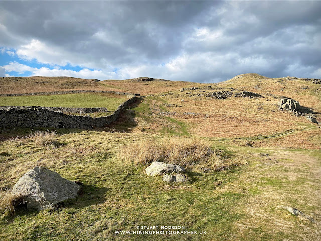 |
| Once out of the car your straight into the steep-ish uphill section which will get the blood pumping. The path is pretty well marked and well trodden and will take you about 15 mins - depending on how many times you want to "stop to admire the views" :-) Once at the top of this hill, the summit of Hallin Fell is not far off at all. |
 |
| And here we are nearly at the top of Hallin Fell looking over Ullswater towards Pooley Bridge. |
 |
| The stone Trig Point of Hallin Fell is huge, and you can't get a sense of scale here, but it's well over 10ft and you can see it from miles around. |
 |
| The views are incredible on the top of Hallin Fell and it is definitely worth spending some time here to soak it all up. We are looking in the opposite direction here to the photo above, towards Place Fell which is obscuring Glenridding. You can just about make out Helvellyn in the far distance near the cloud line |
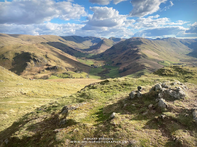 |
Shifting our gaze again around further you can see teh valley of Martindale common in the centre leading up to the summit of Beda Head and The Nab. The next valley to the right of the picture is Boredale
|
 |
| It's time to head back down from the summit of Hallin Fell, but before we do it's chance to take one last look at Ullswater. In this photo the town of Penrith is illuminated by the suns rays and is visible in the far distance, with the Pennines beyond on the horizon. |
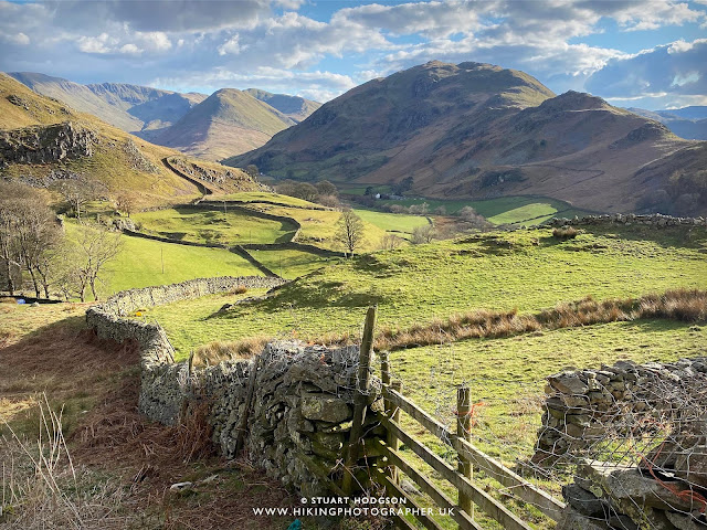 |
| When heading back down from Hallin Fell to the car park you'll get more superb views up into Martindale. Beda Head is largely in the shadows here, with the distinctive pyramidal like shape of The Nab being lit up by the sun at the head of the valley. |
And there you go - I hope this blog post gives you a bit more information on Hallin Fell and makes it easier to plan a walk to the summit of Hallin Fell. As I said it's a short and quick walk, but with superb 360 degree views. And if your new to Lake District walking - then it's an easy way to bag your first Wainwright.
Happy Hiking!
Post by Stuart Hodgson
'The Hiking Photographer'
Subscribe to my monthly email newsletter to stay up to date with all my outdoor adventures, including my latest photos & walking blog posts, as well as a whole host of tips & interesting stuff for outdoor enthusiasts, just click the link below to subscribe.
FOLLOW ME
Not all my adventures & photos end up on this blog -
Give me a follow to see what else I've been up to!


No comments
Post a Comment
Thanks for taking an interest in my blog, all comments and questions are welcome! Best, Stuart